
North Surrey cycling map has gaps to fill, says bike advocate
Surrey’s growing cycling network has to address some gaps to increase safety and promote cycling, according to a co-chair of the city’s HUB organization

The cycling network in North Surrey is growing but there are still a lot of gaps to be filled, says a local bike advocate.
At Surrey’s 13th annual Earth Day festivities in April, the city unveiled an outline of protected cycling routes that will be developed in the City Centre, Whalley and Fleetwood neighbourhoods in the coming years.
Within the next year, Surrey plans to expand bike routes on five roads within the City Centre district including 100 Avenue, 140 Avenue and 144 Street. The expansion proposals were announced simultaneously with a new two-year electric bike share pilot project that launched in City Centre on April 27.
A proposal on 100 Avenue, which will extend a bike lane on the street from 148 Street to 156 Street, is a much needed improvement in the region, Tim Yzerman, co-chair of the Surrey and White Rock HUB Cycling group, said to the Citizen shortly after the map was unveiled.
As it currently stands, the bike lane switches terrain far too much for his liking.
“Using that you got [a bike path] from City Centre to 148 Street, and after that you got a shared lane,” said Yzerman, who has been advocating for more protected cycling lanes in the city’s major roads for roughly a decade.
“It goes from pretty nice to pretty bad, pretty quick.”
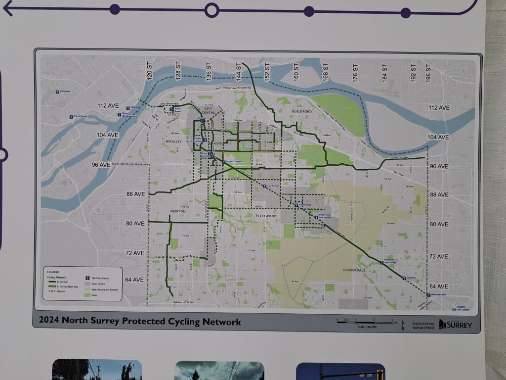
The discrepancy is one of many gaps that is currently plaguing Surrey’s cycling network.
Surrey has an online roadmap of all its cycling routes and ranks the paths in three categories from “comfortable to most” to “comfortable for few” based on its separation from traffic.
Although the city has done a good job of outlining the routes on the roadmap, Yzerman said the map that was presented on Earth Day can be misleading. He wished the city streamlined accessibility on all of its cycling routes.
“There’s some routes that are not too bad to ride on, and some routes that generally are just not complete,” Yzerman said.
The level of comfort on a bike route on University Drive in City Centre, for example, switches three times going north and twice going south between 108 Street and Old Yale Road, according to the online roadmap.
“There’s only a couple sections where you can ride on a protected lane,” Yzerman said. “You might have to cross the street to make it work.”
All of the protected routes are part of Surrey’s 10 year servicing plan to promote cycling in the region, the city’s engineering department said in a statement to the Surrey Citizen in the summer. The new cycling infrastructure will work in tandem with public transit and connect other regions of the city together.
“North Surrey is an area of high cycling potential with connections to SkyTrain and other local destinations,” the city said.
The gaps are a valid concern and an issue that the city is working to fix, said Rafael Villarreal, Surrey’s director of transportation. The gaps may be a result of the city not having access to right of ways or utility infrastructure causing a block.
Other times, condo developers also build cycling infrastructure as part of their new housing project, which may cause discrepancies in riding comfortability.
“If there’s [a development] that is immediately coming, it would be bad for us to build something and then rip it off for the developer to put it in,” Villarreal said. “We are trying to make more of an effort, at least in North Surrey initially, to close those gaps.”
The shifting quality speaks to a larger problem for the majority of bike routes in Surrey, Yzerman says. There are not enough continuous and protected cycling paths to promote easy bike travel.
“There’s really only one east/west [route] that goes all across Surrey following the hydro right of way,” Yzerman said. “Aside from that there’s not a lot of places that cover large distances.”
In the protected network proposal, Surrey is also aiming to install bike infrastructure along King George Boulevard, Fraser Highway where the new SkyTrain line will eventually connect to Langley, and 84 Avenue between Bear Creek Park and 168 Street.
Villarreal hopes the protected network in City Centre will be complete in three to five years.
Beyond that, the city is looking to connect all of the major town centres through cycling routes, a move that Villarreal believes will create more vibrant and attractive areas within Surrey.
“We are just getting to that next level of becoming a city that is not just a suburb of Vancouver,” he said. “It’s going to make us proud to be here in Surrey. There is no vibrant city with no cycling.”
Yzerman would like Surrey to copy what Vancouver has done by creating multiple protected bike lanes in its downtown core, as opposed to routes that alternate between the road and the sidewalk.
University Drive in City Centre would be one route that would benefit from an extended route following that design, he says, especially as the city launches its new e-bike share program in the neighbourhood.
“Say you’re on a multi-use path and it’s on the north side, then it’s on the south side for a few blocks, and it’s back on the north side, it makes it pretty tough to ride on,” he said.
“It’s one thing to make lines on a map, it’s another thing to make cycling infrastructure that works well.”
Author

Comments (0)
There are no comments on this article.